Been awhile since I’ve written one of these. Let’s see how it flows.
THE DRAINING OF LAKE POWELL
Today, we tour the feeder canyons which sidle in to Lake Powell. Powell, by the way, is whittled back down to the old river channel of the Colorado it used to be at Hite Crossing. A few weeks back, I had to scramble to near the confluence of White Canyon and the old Colorado River channel before the mudflats gave way to the dubious beauty of the many fingered, aquamarine serpent bequeathed us by David Brower, who traded the beauty of Dinosaur National Monument for the inundation of Glen Canyon. He didn’t realize what he, as executive director of the Sierra Club, had traded away until it was too late.
Anyway, seems like Glen Canyon wants its old groove back. It has reclaimed a few miles of itself at the northern end of the lake. At the time, I was told by someone who works the Hite Marina that the drain represents an intentional release at the penstocks to save an endemic fish species. I read elsewhere that it was drought. Spring runoff in 2013 was 47% of average. Lake Powell’s summer peak in 2013 will be the lowest in 9 years. Time will tell indeed whether the most engineered river on earth can continue to fill basins like Mead and Powell. As I edit this piece a year later, articles have appeared which talk about Glen Canyon Dam reaching a tipping point where it won’t be able to generate electricity to supply the conurbations of Vegas and Phoenix. In that case, the plan is to tap regional reservoirs upriver at places like McPhee Reservoir in southwest Colorado, a few miles from my home.
The severity of the drought, perhaps the most extensive since a mega-drought dispersed Ancestral Puebloan civilization nearly a thousand years ago, can best be seen from an anomalous, silver-arched bridge over the Colorado here at the north end of Powell. Highway 95 winds itself in loneliness over the river at Hite Crossing. It’s the only way through this northern end of Glen Canyon. Highway 95 caps the red and green of Cedar Mesa, a misnamed landform, for Cedar Mesa is in reality a Delaware-sized plateau which contains the soaring landforms of the Bears Ears, the cathedra fin of Jacob’s Chair, and aptly named Cheesebox Butte. If you get up early enough in the morning, you can drive this two-lane blacktop for hours and not encounter another vehicle. Only a handful of structures dot its waysides from its beginning south of Blanding, Utah, all the way to the next town, Hanksville, clear over 100 miles.
The CD in my pickup was broken. It wouldn’t release the disc, though it would play it. So I listened to Moby (track 3) over and over and never tired of the soaring melodies, a perfect accompaniment to my 6 cylinder, 6 foot bed Silverado and the secondhand, popup camper which road its back like a tortoise shell.
This red dust land, without a single hamlet for dozens of miles, seems like the back door to the relative civilization of the Mormon Front along Highway 191 in San Juan County, Utah. In the last few weeks, I’ve been rummaging around out here. I wandered over the western fingers of Dark Canyon, a terraced and deeply incised gorge created by an anonymous perennial stream at its floor over 1,000 feet below. It’s western reaches were Grand Canyon in miniature.
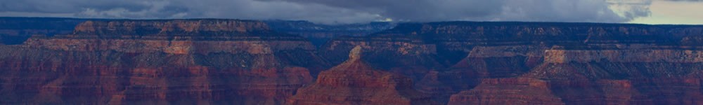
BLUE NOTCH CANYON
Two weeks later, there was Blue Notch Canyon. Of all the canyons which spilled into Lake Powell that I had explored, Blue Notch was widest and longest, and in places a reminder of Canyonlands farther north. A recently re-graded dirt road leads down from the pass of Blue Notch to Good Hope Bay. The hardest segment of the hike – up a steep grade to Blue Notch – is reserved for last.
My seven hour round trip foray to the bottom of Dark and back over a talus scarp that dropped 1,000 feet in one mile tempted me into thinking I was fit enough to attempt to reach Powell from the magnificent view of Blue Notch in a single day.
It’s an hour’s drive for most vehicles from the Notch to Good Hope Bay. It was 10 hours for me on foot, maybe about 24 to 28 miles in high desert sun, give or take a few lifetimes. Emptied of water and food, I made it back to the Notch in time for sunset. I watched the dusk settle around the shoulders of Mount Ellsworth, the southernmost of the remote Henry Mountains. At the end of Blue Notch Canyon, Ellsworth rested like a bust atop a pedestal of rust cliffs which formed the western shore of Lake Powell. What a view. What a walk.
Before I’d left for Blue Notch that day, I’d stopped in at Hite, and an NPS worker greeted me at the grocery store with blue Playtex dish gloves, stating that he had been cleaning up piles of mouse shit. Since I’d touched the handle of the door after him, I assumed, as I lay in my camper that night after a 24 mile walk in the sun, that my delirium was caused by the sudden onset of hanta virus caught from the man who cleaned mouse crap.
My naked body boiled in the heat and I shuddered in the non-alcoholic version of the DT’s. Every time I shut my eyes, kangaroo people appeared. They had satir-like kangaroo bodies with human heads. Boxing promoter Don King’s head on a kangaroo body assaulted one of my coworkers, who was also a kangaroo person. The fights were scored by the music of cat fighting, complete with screeches. I had the hanta virus and I was dying a few million miles from where anywhere last knew where I was. I awoke the next morning, having made a miraculous recovery.
The view from Blue Notch made up for everything that dawn. I hiked up from my campsite a couple hundred feet below. The canyon broke up into wide sections of Wingate sandstone cliffs which spun down to greened draws of white rime. Cliff-forming Wingate defines all these feeder canyons with its deep auburns cured to amethyst by a setting sun.
The blue of Lake Powell, which had goaded me into thinking I could get down to the shore in a couple hours from the Notch, still tempted me. But I didn’t want another bout of fake hanta. Mount Ellsworth stood in a jagged, obsidian-like relief with the sun to the east.
FARLEY CANYON
That day, I drove west along 95 and exited left to reach Farley Canyon, which also feeds into Powell. I drove down near its confluence with the lake. I walked the cliffs along the east shore, almost stumbling over dunes of white snail shells and negotiating debris fields that, like a glacial moraine, showed the water mark for Powell at full pool. Telephone poles and railroad ties littered the shoreline. I half-expected a baby stroller.
At sunset, I scrambled atop a high mesa and let the wind knock me around. I’d been reading an anthology of mystical poetry from all over the world, The Enlightened Heart, translated by Stephen Mitchell. The mystics write about the ineffable experience, about how it cannot be put into words. I find their descriptions of egoic annihilation and the great void of nonbeing oddly comforting.
I watched the sun dip behind the summits of the Little Rockies, a southern spur of the Henry’s, from yet another mesa top of crumbling burgundy stone. The wind wouldn’t relent in its ferocity. I wended my way down the mesa. That night, I camped on a hillock next to highway 95.
Next morning, after a surprisingly traffic-less night sleeping neat the shoulder of Highway 95, I followed my intuition and headed west toward the Henrys. I stopped at Hite Overlook. I could see far down the canyon which once held the waters of Lake Powell. The old river channel hugged first the west scarp, then wandered over the flat silt plain to the east cliffs. A wide, flat riverbed separated low lying escarpments which marked the first benches of Glen Canyon on either side. I tried to imagine the drowned, old West town of Hite at the bottom, where it must have burgeoned with cottonwoods and willow, but I saw only the unclaimed sand, repopulated by sedge and salt cedar.
To the east, the Colorado swept under Hite Crossing and wandered in a narrow channel through sheer cliffs crowned by ivory caprock the shape of mushroom heads for miles. The narrow, hard-walled gorge reminded me of Marble Canyon farther south, or of Cataract Canyon nearer to Canyonlands. Numberless buttes and mesas rose and fell in the northeast to the horizon. To the north, a wide canyon marked the entry of the Dirty Devil as it flowed toward its confluence with the Colorado.
STARR SPRINGS
And so I moved on, down the magic of Highway 95, the most scenic of scenic byways. Winds and the occasional storm off the Henrys buffeted the rounded ivory of Navajo sandstone and the bleeding rust of Wingate, scouring sand off of boulders, from sand to stone to sand once again.
I turned south without a clear idea of where I wanted to go. The full length of the Henrys lay like a giant on its side for 30 miles north to south, from the heights of Mount Ellen, the highest in the range at over 11,000 feet, past Pennell, set back farther west, and down to Hillers, lowest of all the main peaks.
The Little Rockies, capped by scrub and P/J woodland, bore tawny colors, not the cold cobalt and granitic gray of the main massif of the Henry’s. Mount Holmes and Mount Ellsworth had sharp, jagged glass peaks. Their height, their color and their shape bore more resemblance to Basin and Range peaks in Nevada than in the heart of the Colorado Plateau.
Situated just off Highway 276 between the Little Rockies and the base of Hillers, I camped at Starr Springs, an oasis just north the Cane Spring Desert. Flush with tall oak and even taller cottonwood, the oasis was named for Al Starr and his abandoned ranch. Starr settled this land in the 1880’s and had his huge house built with a well-constructed cellar. He wanted to raise horses and mine ore up in the mountains here. Drought came. It conspired with loco weed to kill off most of his herd, and his mine never did produce commercial-grade ore. I felt sorry for him. One more forgotten venture man whose failed endeavor ended up a state park.
I got a camp spot, strapped on more water than I’d never need (which beats what I did at Blue Notch), and headed up Hillers Mountain Loop Road. Storms warned overhead with dark steel blue hulls. But I wanted up. And only thunder would turn me back.
Boom.
The ‘angels are bowling’ of thunder knocked, the kind one hears often in the cooler mountain climes where storms coalesce. I waited in a juniper thicket until the large beads of cold rain and the unmistakable whiff of petrichor passed.
The Henrys are a remarkable laccolithic range of the species that dots the southwestern region of the Colorado Plateau. Tens of millions of years past, subterranean chambers of magma bulged and swelled the overlying sedimentary strata and intruded into them. The softer sediments gave way to erosion, leaving the igneous cores of isolated ranges like the La Sals and the Abajo, Sleeping Ute and the Carrizo, Navajo Mountain and the Henry’s, which are the last mapped and named range in the lower 48. John Wesley Powell hailed them the Unknown. The Navajo called them the Unnamed.
I decided to scramble, but as old Providence would have it, the place I chose to bushwhack up the mountain turned into an abandoned two-track road. I followed the ruts until they pinched out, and then wandered up through the P-J. I hiked in the rain shadow of Hillers beside clumps of sage.
I climbed talus fields of sharp, sorted-through boulders, fell, grabbed hold of an old sage bush and it had the nerve to cut my palm. A storm that had past farther east rumbled again and again over the canyons, and I kept a close watch on the movement of the clouds against the peaks. Storms threatened south and north, trending east, but so far, nothing wicked my way came. I reached an altitude which seemed to be within a few hundred feet of the summit. Gravestone gray fins hundreds of feet tall leaned in the thin soil. Shaped like blunted teeth and incised at shallow angles from the vertical, the stone reminded me of the flint hue of the Sierras.
I climbed out to the edge of a promontory as far as the jumble of boulders, dotted with pinion and Mormon tea, allowed. From there, I made out the tilted, monocline saddle that connected the twin peaks of the Little Rockies with one another. Beyond them, the distant hump of Navajo Mountain haunted the desert.
The east was an indecipherable series of horizons of red and tan stone that made up the ramparts of Glen Canyon. A blue finger crooking through the canyons marked lake Powell’s receding waters. Far away, on the last horizon, the paired buttes of the Bears Ears pointed toward a mixed sky torn with indigo and scarves of white and quicksilver. As my eyes scanned northeast, the high mesas on the plateau of Cedar Mesa broke any sense of flatline.
But it was the west that drew my eye and my spirit, where far off cliffs cast back subtle shadows. The Circle Cliffs stretched their ragged, boney fingers into the chasmic plains of Scorpion Flat.
In the center, Navajo Mountain stood so alone. Even the relatively isolated laccoliths of this plateau region keep the company of chains. The Abajo, the La Sals, the Carrizo, the Ute Mountains, the Henrys; they are all small chains. But Navajo Mountain, the Dine’s sacred mountain of the west, was a true monadnock, a singular mound standing 10,000 feet tall, marking the passage of the San Juan River to its north, straddling the Utah-Arizona line, and guarding the northern bounder of the vast Navajo Reservation, which yawns with scarp and canyon and trackless mesa. Navajo Mountain’s sheer northern escarpment fell sharp to the north, its naked rock plunging to the high desert. It was an mistakable landmark for so many miles of heat and solitude. I wanted, from this crows’ nest, to watch it change as the sun moved across its face, until darkness fell. But rumbles over my shoulder spurred me to climb down before the rock became slick with rain.
I decided on an uneasy route at the southern flank of Hillers, which spilled in jagged stair steps down to the relative flat of the pinion-juniper a few hundred feet below.
“No one knows you’re within 40 miles of this place,” my insides told me. But a deeper place inside told me to risk it anyway. So I climbed the spliced rubble pile and boulder mélange until I hit a navigable wash. I hiked back toward the road.
All my life, I’ve stood at the edge of a high dive, asking the Universe to take away my fear, so that I could jump in. The Universe seemed to whisper in reply: “Dive, and I’ll take away your fear.”
Most people, myself included, construct at least a part of their lives as a defense against that which they fear. We build walls, either out of concrete and barbed wire or with the aloof look in our eyes or by pouring ourselves into Facebook, where we only friend the people we like, and where cyberspace creates a distance greater than width of Glen Canyon. I’m 51 years old and I’ve resolved to die a dangerous death; to fall somewhere off a cliff. Not on purpose, since I can’t take life that seriously. But only because to live an insulated life translates to an existence, to a formulaic reaction to what I think threatens my life, but which in reality represents the greatest threat to its vitality. If there be an afterlife, I won’t lose points for falling off a mountain instead of dying of old age in a nursing home.
[To get to the places described in this post, take Highway 191 to just south of Blanding, then hitch a ride on Highway 95. You’ll know when you’ve arrived].
© 2014 by Michael C. Just