Take Temple Junction/Goblin Valley Road to Temple-Junction-to-Hidden-Splendor-Road (that’s all one name). Keep driving (or walking, as I did), for about 1 ½ to 2 miles. The pavement will end, but you’ll keep walking. You’ll track Temple Wash, a deep and ruddy affair, for awhile on the right. You will pass a rusted sedan the same color as the Wingate Sandstone which makes up much of the Wash’s bottom. Keep going.
Your camelback may spring a leak, as mine did. The soaked sensation of warm water clinging to your clothing at the backside may bring back preverbal memories of toddlerhood. You may not be able to use this camelback again. Too much bedwetting trauma.
Just past the edge of Temple Mountain, look for three cairns and a pullout for a primitive campsite. Follow the road past the campsite into a canyon. Follow this road past a series of raised firepits, expertly constructed, where you may find broken dishes and rocks someone colored with brightly hued chalk. You’re not there yet.
Pass two more firepits which have some logs and other wood fuel next to them. The road becomes a wash at this point. Trace the wash to one last firepit with a giant cairn behind it. A red Wingate cliff will stand in front of you, roughly trending south-by-southwest.
To the left, a scree hill of Mossback strata will stand out due to its yellowness, the same color as Temple Mountain far across the main road behind you to the north. Climb the hill to your left, or the cliff in front of you –
whichever you find more accessible – to the top of a mesa.
At the top of the mesa, you will find a large, raised firepit. You will also find a large armchair composed of sturdy flatrock, complete with arms (or it wouldn’t be an armchair) and a sturdy back. It may look to you as if it would fall apart if you sit in it, but it did not for me.
Next to this, you will find an end table for your glass of sherry, should you bring one. You will also find what appears to be a couch. Thank the people (most likely young, energetic types) who built this outdoor living room. Then, lounge about in their furniture.
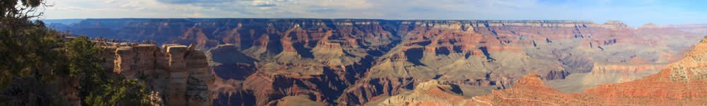
Directly to the south, you will enjoy views of the northern aspect of the Henry Mountains; to the southwest, the plateau of Boulder Mountain; to the west, Thousand Lake Mountain, a universal blue.
To the east, the broken reef of the San Rafael Swell let in views of the desert flats beyond, plains that seemed to stretch the dozens of miles until the La Sal Mountains come into view where the earth warps over the horizon. Between the gaps in the reef, the sun shows the wrinkled, accordion relief of Gilson Butte which sits near Highway 24, the only paved route through the region. 24 connects I-70 to the north with Hanksville and Highway 95 in the south.
Thunderclouds blow up on Cedar Mesa, far beyond Lake Powell. I’d watched thunderheads all my life. These resemble the mushroom clouds from nuclear detonations more than any other I recalled. I suspect that the world of the humanoids finally self-destructed. How nice of it to wait until I was out here, where, miles from a settlement of any size, I would survive for awhile on the nuts and jerky in my camper.
WASHOUT
Next day, I drove down to Hanksville with no clear destination in mind. I veered left at the junction, which is all Hanksville really represents for non-denizens. West of town, on the way to Highway 24, the land devolves into a badland, scorched and boney. The odd juxtaposition of cottonwood and willow lining the banks of the Fremont River, backed by lifeless mudstone and siltstone buttes and mesas, jarred me. To the south of the highway, above the bleached land, red mounds build up to the blue of the Mount Ellen group in the Henry’s. Above those igneous summits, thunderheads swelled to their mushroom shapes. Nowhere else in America I have seen such a strata of contrasting worlds. It culminated in the Upper Blue Hills and Factory Butte on the north side of things, with its sharply sculpted scarpface relieved by shadows hewn by morning sun. A road to the south led into Capitol Reef, and I took it.
I stopped in the town of Notom, where city fathers and mothers had erected a plaque outlining the history of the settlement along with the town anthem. The toothy Water Pocket Fold unfolded above the soaking green of the settlement, with the far off azure of the Aquarius Plateau rising and diving like a whale’s back above the Fold’s froth.
The gravel of Notom Road continued on for 40 or so miles. After negotiating a muddy draw, I took the chattery road, which threatened to shake my jiggling camper to pieces. The west flanks of the Henry’s, limned by vernal, irrigated bottomland, was castled with vast hay stacks half-covered in sheaths of white plastic. I drove south down Notom Road until a low and sharp escarpment swallowed the whole eastern scene of mountain and valley. The monocline of Capitol Reef tilted up giant stone entablatures the size of baseball diamonds. At 60 degrees from the horizontal, the dotty forests of juniper and pinion grew like ephemeral weeds on up heaved asphalt. Beyond that, the blonde domes of the Reef swelled to the horizon.
After a long drive, I crossed over an unpoliced boundary into Capitol Reef National Park. No one took this back road; not in summer anyway. I’d passed one parked pickup all the way up ‘til now. It didn’t seem like national park. No entrance station or entrance fee or entranced tourists. The well-graded, washboard road twisted through the desert. The jagged, colorful reef paralleling on the right. I drove a long way across those runnelled roads in search of the feeder canyons into Lake Powell. But unless I was on a desert trail, I seldom kept to my original plans for long. A sign for Lower Muley Twist Trail hooked me.
I parked and strapped on my fanny pack. My tall, liter bottle of Smart Water in the center socket of the pack was somewhat larger than the socket itself. I appeared as if I sported a jet pack. The road to the trailhead bottomed out into a dry mud wash. A recent flood had undermined the gulley floor on one side. It seemed on the verge of failure and coming rainstorms building east in the Henry’s would make it impassable. I was glad I parked on the main road.
Near the trailhead, an NPS Ranger vehicle droned up from behind, seemingly out of nowhere.
“Do I need a permit?”
“It depends. What’re you planning to do?” He was a young, burly sort with rusty hair and a local accent.
“I heard about this trail from a canyoneer friend of mine from California. She hiked it, and the way she described it, I figured I’d give it a try.”
“Where’s your vehicle?”
“Oh, I parked about a quarter-mile down the road.”
“No, you don’t need a permit,” he said, eyeing my measly fanny pack with the bottle of soft clear plastic jammed into the socket like an oxygen tank. It was July, and this was desert. “If you don’t mind me asking, how far do you plan on heading in?”
“Oh, just about a half an hour, 45 minutes.”
“Because with this heat . . . ,”
The way he completed that sentence in his mind?
. . . and that 51 year-old body, not wearing any rescue colors? 102 degrees? A sharp rise in the trail through the cliffs? You, sir, are a Class A Idiot.
I assured him I’d only head in for a short time, and gave him a list of my bona fides over the past few weeks in the region, canyon-wise. He seemed convinced I would not require him to hike up into the cliffs in order to rescue my sorry ass, and he wished me a good hike.
I took the open land up into the dome rock of Capitol Reef. After about an hour, I nearly summited the ridge. The ranger had parked down by the trailhead and I’d disappeared from his view. I didn’t want him thinking that’d I’d run out of water or tumbled out over a bench, only to confirm his sense of my Class A Idiocy. Besides, my water had risen to pee temperature, and was half gone. Time to turn around.
As I danced down the trail, the ranger’s NPS vehicle parked near the trailhead, eyeing me with government eyes, turned into a picnic bench. I regretted not topping out at the top of the Reef, but I’d gotten some unparalleled views of the Henrys and the Little Rockies, and I had that most superlative of experiences: I had not seen one another human bean.
My plan was to drive down to Bullfrog, pick up the ferry across Lake Powell, and ride from Hall’s crossing across Cedar Mesa from Hall’s Crossing until I reached home. A fork in the road gave me the option of returning home overland, via an outlet onto Highway 276 near Starr Springs, an oasis at the foot of Mount Hillers in the Henry’s. I took the left and headed toward the Henry’s.
The view had made my decision for me. Canyons, white and rimy, scraped bottom at the basement rock of Mount Pennell. Lines of redwall buttes and mesas reminiscent of Canyonlands stepped up to the pediments of the mountains, which vaulted to a height of 11,000 feet. Hillers, Pennell and the Ellen group formed a straight line which backed into the western canyons like vast slag heaps plummeting into quarries.
Looming over Ellen, a new mushroom cloud had formed, its wide, vertical shaft surrounded by a planetary ring through which it shot with a blow off top wiping into the tropopause. Mountain and storm, alluvial fans emptying into canyons, all of it vast and lunar and inescapable. My road merged with a wash and lapsed into an impassable mudflat that twisted beyond sight through a low and shallow canyon.
I got out of my truck and left it running. Dipped my fingers into the mud. Toothpaste. Too rich to pass through even with my wheelbase and my treads. The truck idled behind me for direction, an impatient horse in want of its rider. My gas gauge arced like the sun towards its inevitable set at E.
I turned around and drove back up toward the fork in the road miles away, then headed toward Bullfrog. I could gas up there before I hopped on the ferry. At some point along the journey, Notom Road becomes Burr Trail Road. The gravel ends and the asphalt rises to a hogback that offers spinning views of pure verticality on either side of the narrow and rugged shoulder. To the west, Capitol Reef gives way to the Circle Cliffs. Between the hogback which my blacktop straddled and the cliffs west, a tawny canyon rose and fell, bunching with tortured rock folds thrust up in zigzag strata.
Along the east shoulder of my road, the land plummeted a thousand feet or more straight down into a redwall abyss. I couldn’t locate the canyon on any map prominently, and a Google search later didn’t much refer to this staggering beauty which fed, via its water engorged wash at Clay Creek, into Powell proper. But the dimensions and yawning depth reminded me of the Little Colorado River Gorge just before its confluence with the Colorado at Grand Canyon. That kind of majesty. I was in Glen Canyon National Rec Area now, so I could have simply turned off the road and camped on the ledges. But I only spotted a couple of primitive turnouts.
Side canyons plummeted into Lake Powell in the distance. Redrock, scarps, buttes, and the far off mesas of Navajoland opened up to the southeast. The Henry’s seeded with storm. I stopped a couple times to take in the view. The tiny creek thousands diagonal feet below almost became lost in the defile it had carved. Later, I learned that this was Clay Canyon.
I drove on toward Bullfrog. It was getting late and I had a long, long way home. Up and over a hill, I braked hard as I neared the bottom of a wash. Water flowed through mud slurry and it did not look good to cross. I usually overestimated these kinds of things.
Class A Idiot, sir, you might want to turn around and go back, I heard that NPS ranger from Lower Muley Twist trailhead say. But I had about 60 miles of serious washboard in front of me if I didn’t cross this stream.
So I got out of my horse and surveyed the scene. Walked up to the wash. Stuck my hand in the mud. And it was deep. I couldn’t hit bottom. And it was Ben and Jerry’s Chocolate Chip Cookie Dough after you nuked it for about half-a-minute in the microwave.
Just then, a black SUV pulled up on the other side of the asphalt road. I hoped it would have just paddled on through, to make up my mind for me.
The driver got out and scouted the stuff. Looked downstream.
“Doesn’t look good,” I said.
“No. I really wanted my girls to see Capitol Reef,” he said.
I looked upstream, where the mud seemed firmer for a short stretch.
“Looks like we could try crossing over there,” I said, “but I might tip right here.” I pointed to a steep incline in the bank. “I’d likely high center on that, and roll over.”
“Yeah, your truck’s kind of heavy with that camper. You might just sink down into this shit.”
“Yup. Almost outta gas, too.”
“Don’t know what to tell you.”
His girls got out of the SUV.
We stood, he and I, like Romeo and Romeo on opposite sides of a small but unbridgeable moat, still calculating the odds despite our hopeless talk.
“You gonna do it?” I dared.
“Nah. Not with the kids. Can’t take the chance.”
We headed back to our horses, jumped in, pulled three-point turns, and headed back in our respective directions.
I watched the Henrys above treeline fill with rain. A handful of dry washes I’d crossed on the way in, all caked with recently dried mud chips that resemble potsherds, might soon fill with water ahead of me and I’d be stopped out for the night.
“People depend on me!” I shouted at the rain in the mountains. “I have responsibilities!” I drove fast over the washboards and discovered that if you did that, it didn’t rattle your brain and loosen the tiedowns on your camper so quickly. You almost floated over them. That was also what caused washboards.
I drove so fast the truck skidded sideways a few times. “Why did you do this to me!?” I cried to the god of misadventure who’d lured me into his trap. At best, I’d limp into my driveway at around 11 o’clock and miss TV baseball tonight. “OH MY GOD!”
Shirtless against the triple digit heat, with a sweaty, behatted head of spiked hair once I unbehatted, unshaven and unwashed for days, I looked like a meth cook who’d sampled the batch too many times as I passed a young woman in an SUV heading in the opposite direction. I waved and shouted HEY for her to stop and listen to me on this lonely road as she headed toward certain, mudded doom. I, the washed out, watchout! washout prophet. She drove even faster.
A second vehicle passed and I waved him down. I backed up. He backed up. Two twisted sets of tire tracks in reverse, a couple of drunken ants as seen by the god of misadventure, laughing above.
“The road’s washed out ahead,” I shouted over the chug of our motors. He had Utah plates, this young man with his wife and kid. He consulted his map.
“What about the road to Starr Springs?”
“That’s even worse,” I told him. I, the Paul Revere of mud.
We chatted for awhile. I checked out his ride, a Nissan Pathfinder. No slouch, but man, that mudflow ahead of him was bad.
“What’re you gonna do?” I asked.
“I don’t know.”
“Well, I’m gonna head out before the rain in the mountains stops me out. I’m worried about that V-rut at the top of Notom Road. You know, by that ranch?”
“It was dry when we went through,” he said.
“Okay. Good luck.”
I sped on, kicking up a cloud of graveled smoke that hazed my rearview past. A low rider VW rental with California plates bulged up in my windshield future . I flagged down the driver, a young Dutchman with his Dutchwoman, and warned him off the pyroclastic flows sure to embed him in La Brea doom ahead.
He didn’t seem to understand, so I explained again, checking out the frame of his car. This guy definitely wouldn’t have made it. Yet he kept driving toward it, too. I guess everybody has to figure out things for themselves. After all, each vehicle I encountered here had driven a few hours just to get this far.
On my way out, all the gulches remained dry. Water damned up roadside at each arroyo on both sides of the road, waiting to build force enough to breach tiny mud dams formed by road graders and reinforced by each car that came through. Cobalt drapes of rain painted the sky, with curtains of virga and crepuscular shafts of sunset decorating the storm on either side. I made it home by 9 o’clock. I even watched the last inning of the ballgame.
Alost, almost. Almost nothing alost. Trust the moment, for only the present is worthy of trust. Following an inner guide, with a dose of discretion as the better part of valor, as my father used to say, always brings me home safe, with the bragging rights of an adventure in my pocket.
[My misadventure began westbound off Highway 24 west of Hanksville, just east of Capitol Reef National Park. I took Notom Road south, or left, from 24 and drove many miles on well-graded dirt until Notom became Burr Trail Road. Eventually, you will reach blacktop again at Highway 276, where you can reach civilization again, eventually. Experienced Jeepers will tell you to avoid the washes when they’re wet.]
© 2014 by Michael C. Just