Highway 50, wandering east-west through Nevada, is billed as America’s Loneliest Highway. I can’t believe it’s any lonelier than some of the other highways I’ve travelled (95 in Oregon, 278 or 225 in Nevada, 51 in Idaho). Still, it’s pretty damned desolate.
A vast, wandering playa stretches south, some of it mirrored with a recent, rare rain (rrr!), about 45 miles west of Great Basin NP. Shattered glass mountains, low ranges, enfold the lake. The water a trackless sheet of reflected sky, the treeless mountains diamonds in the half-clouded skies. All painted a perfect still life by the lake.
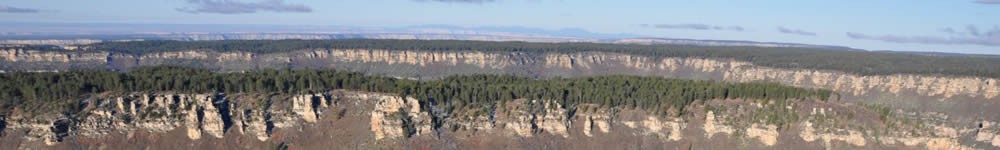
Basin and Range topography differs from Colorado Plateau landscape. Great Basin landforms are more tilted, less vegged, the strata often more apparent, the mountains more abundant as opposed to the occasional laccolithic ranges of the Plateau. Basin and Range mountains tend to be lower and sharper, the valleys flatter, and there are fewer miscellaneous landforms such as mesas and buttes. Throw in the salt flats, and mountain ranges that vault straight from valley floors along more or less straight axes for dozens of miles, providing an artist’s lesson in perspective. The ranges foreshorten toward the horizons of valleys and finally disappear, like an unending line of sea cliffs that only the horizon snuffs out. Then, FOR SALE: 5 ACRE LOTS! Thus goes the neighborhood.
You drive east through a wide, planed valley. A massive, mountain wall rises at its eastern end near the Utah border. A prominent peak still capped with snow in late May, taller than all the rest, means you’ve reached Wheeler Peak, at over 13,000 feet. Its singular stature imposes itself 8,000 above the surrounding valley floor. It stands out from a massif of other peaks in the higher, southern section of the Snake Range. Wheeler, the highest freestanding summit in Nevada, seems similar in some respects to Pike’s Peak along the Front Range of the Rockies near Colorado Springs, though the orogeny – the origins of this range – are quite different from the Rockies.
If you’ve reached this point and continue on over Sacramento Pass, you’ve reached the Snake Range, a 60 mile long highland that presides over the high desert of the Great Basin. You may note that ranges here have a higher base-to-summit rise than the Rockies and most other ranges in the U.S. As the earth’s crust pulls apart (rifts), faults cause massive blocks of stone to drop down, forming valleys or grabens, while other blocks right next to the downdropping grabens lift, forming mountains or horsts.
On the other side of this titanic uplift, you’ll find Great Basin National Park, a desolate mountain retreat known for bristlecone pine (the oldest freestanding organisms on the planet), along with Lehman Caves.
I camped out at Baker Creek Campground, nearly deserted this time of year. I took Baker Creek Trail to Baker Lake, plowing through silken snowdrifts up to my knees. Sometimes using postholes punched through by other hikers, sometimes drilling my own postholes. I was alone the whole day.
I almost made the lake, but stopped in the shadow of the headwall of a gigantic cirque. I’m way above snowline, negotiating dozens of trunks felled from a blowdown or a fire or an avalanche at the foot of the cirque. Huge rock faces, near vertical, now frozen with snow. Filled with gratitude, I become aware that this lonely experience is my dream come true.
I recall many, many years past, watching glaciers calve into a fjord in Alaska. I remember the Alaskan tundra north of the Arctic Circle in Nome, in Kotzebue. I remember Quetico National Park in the Boundary Waters Wilderness north of Minnesota. Wolf River in Wisconsin. The mountains outside Steamboat Springs. What disasters all those trips had been. All I could think about back then was where my next drink was coming from, or my next drug. Or I was too drunk to enjoy it. But now, I can take it all in. If I remain present to Presence, if I remain in the present, to Love, I am in joy. Always. We are the intersection between interior and exterior universes; the arcing loop which connects God to Its lower emanations.
On the fringes of the cirque, Manzanita, pale mountain dandelion, and mahogany ready for the growing season. I’d hiked through Engelmann spruce and Douglas fir. Now, I stood among limber pine. Out of nowhere, it seemed, I reflected on my father and my grandfathers, on my grandmothers, and all who’d gone on. I cried. Told them that I missed them. And though I may never again hear my Opa laugh or my dad curse, I hoped that they could see this blue sky through my eyes, hear through my ears the wind sing through a thousand limber pines. So I took out the ear plugs I used against the cold wind. I smelled sharp pine and the sweet sage and the bitter aspen through my nostrils. I stopped my weeping, and felt Manzanita leaves through my cold-stiffened fingers.
And I thought that maybe I could take more time gazing at the forest. Maybe it was alright to stop at the rushing, bouldered creeks of waters clear and dark, measure with inches of my heart the massive headwall above me through air so clear and far from the lights of men that it offered the best stargazing for a million miles square. I had permission to stop and listen, instead of rushing at the insistence of the petty, loud voice of my ego which demanded that I make the end of the trail so I had bragging rights, transforming desires like that into needs. Instead of marching in abeyance to the taskmaster of time, I could stop and listen to the warning pip of the marmots. For my father, my grandmothers and grandfathers have neither seen nor heard nor tasted this summitted world in their forced, industrial lives, where they toiled as machinist and seamstress, as electrician and farmer to give me a future, they could not know the feel of cold, powder blue air, the sight of bighorn or antelope.
So I can slow down here, and let them experience it through me, along with all their fathers and mothers as well. With boulder-strewn Baker Creek roaring at full-throttle, the stands of aspen leafing out, I didn’t think they’d find a lusher, more alpine, quieter place than Great Basin National Park.
To get here: Just get on America’s loneliest highway (U.S. 50) and follow the signs to Great Basin N.P. The hike up to the cirque took me 2 ½ hours. I didn’t quite make Baker Lake. The snow covered the trail and, well, I lost the trail. It’s 5 + miles one way, and 2,000 + feet in elevation gain to 10,000 feet.
Timber Creek Trail to Johnson Lake
Next day, I set out to actually make it to the end of the trail; a different trail. Timber Creek Trail climbs much more steeply than Baker Creek Trail. In an hour, I enjoyed dizzying vistas of the valley to by north, followed by mountains atop mountains.
I hit a vast meadow where I could gaze upon major peaks in the Snake Range, including the ice-carved formations of Wheeler Peak. Constant wind blasts. Very cold.
The southern flank of Wheeler’s cirque vaults to the Peak’s summit in a massive wave, frothy and foamed, a whitecap with snow covering the south face. Etched relief plummeted vertically down the north face, a dark, snowless headwall. Wheeler’s shark toothed summit razors up and down for a mile or more laterally. I had to wade through some snow, but once I reached the Snake Creek Divide at 9,817 feet, the views in all directions were worth it.
At Snake Creek Pass, pestering gales rocked my world, and so did my view of the more remote but lower summits in the northern section of the Snake Range, across Sacramento Pass to the snow clad peaks in the Mount Moriah Wilderness. Once in awhile, between reading passages of Blake, I took in the tanned, Snake Valley and the Confusion Mountains across the border in Utah.
As they did yesterday, snowfields eventually stopped out the trail, not uncommon in late May. Minor route finding was required. Mostly, for the last 45 minutes, I just followed the postholes gouged by a couple of hikers who made the trip earlier in the season, probably yesterday, I judged, from the freshness of the imprints. At one point the footprints diverged, and I followed the smaller pair (a woman’s, I assumed) to the skirt of a talus slide near the summit. Maybe they had an argument and she split.
Trails’ end is Johnson Lake, a fair-sized tarn walled in on three sides by its cirque. The headwall was pewter gray, and the gigantic, rounded domes embedded in the mountainside reminded me of Sierra Nevadan granite. By the time I made it there, my feet were soaked by the sheetwash I had to slosh through between small lenses of bunchgrass, and by the deep, wet snow. My cold, wet feet and disappearing snowprints prodded me to head down pretty quickly after I’d arrived. Besides, Blake’s Tales of Heaven and Hell wasn’t doing it for me. I followed my own clodhoppers out and retrace my route down.
To get there: The trailhead’s about a half-mile from the Baker Creek C.G. It took me 4 hours from the T.H. to reach Johnson Lake. It took 8 hours on this 11.2 mile roundtrip with 2,620 feet in elevation gain. You’ll encounter some old log cabins and mine buildings on the way up and down, BTW.
© 2015 by Michael C. Just