I live right on the doorstep of – to paraphrase Tony Hillerman – the endless canyon country of Utah that seems to drive its denizens mad with blue sky and trackless solitude. I’ve traversed enough of the state, most of which falls under the physiographic domain of the Colorado Plateau, to conclude that geology has endowed it with more natural beauty than any other state in the Union. Per square mile, it contains scenery which just cannot be matched. Mountains stacked beside canyons. The bleached basins on the western edge of the Colorado Plateau. Well-watered valleys seeming miracles as they pry green from the dry furrows that lie between the Basin and Range and the Plateau.
Over the 4th of July, I decided to land on Dinosaur National Monument, which covers northwest Colorado and northeast Utah. A former NPS ranger who’d worked Dinosaur told me about Echo Park. I’d surfed scenes of this confluence of the Green and Yampa Rivers on Wikepedia. I preferred the austere and forever views a canyoneer could achieve from the rims over the heated and buggy bottoms. I guessed that Echo Park, which my friend had described, was a rim view.
From my Colorado abode near the Four Corners, it took all day to make the top of my state, first riding 491 out of state through Monticello and Moab, then I-70 back into Colorado. I slowed with the speed limit through corrugated metal towns surrounded by dusty plains. Dust devils impersonated the smoky Montezuma Valley I’d left behind back home, where the distant South Fork fire had smoldered for weeks, nightly filling my home with the smell of smoke.
I drank way too much coffee, a diuretic, followed by drinking way too much Powerade, an electrolytic, followed by a ballooning bladder that caused great pain in my back, followed by a speedy visit to a dive bar in Rangely, Colorado, where rangely men sat outside on the rotting railroad ties outside, talking about strangely matters as the seats of their Levis slowly soaked up the creosote. It had been awhile since I’d walked into a dive like that. I never could stomach places like that, unless I had a few belts in me. I don’t think anyone could stomach a place like, unless they had a few belts in them.
Confidence in my renal emptiness restored, I headed up to highway 40 and took a left toward Dinosaur, as the signs told me. First, I had to pass through the Metropolitan Statistical Area of Dinosaur, Colorado. Dinosaur MSA. Bikers, the real one percenters, roared back and forth over the 110 degree two-lane blacktop. This was how Moab used to look before the Italian and Mexican restaurants and Jeepers and La Quinta Inns mounted an offensive and turned it into the Riviera of slickrock country.
Life-sized stegosauruses made of plastic smiled roadside. Riders with inked up arms praying to their ape-hanger god kicked up gray dust as they veered into a lot in front of their club.
I headed west, on to Vernal, Utah. The high peaks of the Uintas sloped gently to the south, still clad with bands of snow. I stopped at the visitor’s center on the east side of town, looked at the giant map on the wall, then headed north toward Dinosaur, the Monument.
Boaters towed their speed boats up toward Flaming Gorge, a Green River canyon that had been inundated by the water wars of the early 60’s. At the National Monument gate, where the Ranger promised me a campsite, the trailers riding in to Dinosaur seemed to multiply before my eyes. The 4th of July. What was I thinking? I was thinking heat, and noise, and little kids toasting marshmallows at 3 a.m., and imagining a moustached man with dancing dogs swallowing fire before the crowds and, oh, the hell with all that. I turned around and headed back toward highway 40. This time, I rode back east. I’d missed the turnoff for Echo Park and my Delorme maps of Utah and Colorado refused to either converge or cooperate. Territories that stretched over state lines made lining things up difficult.
To get to my original destination, Echo Park, I discovered that my turnoff should have been east of Dinosaur MSA, not west. I revisited the visitor’s center in Vernal and encountered behind the counter a kind, elderly woman. On her computer screen, she showed me a fast motion video of the 11 mile dirt road trek to Echo Park. Echo Park was on the bottom of the canyon, not at the rims which I favored. What was happening to my notoriously self-famous sense of travel karma, where I simply looked at a spot on the map, drove, and stumbled into the most astounding adventures and mind-bending sights a trekker could find? I’d spent 10 hours driving from the southwest to the northwest of my own state of Colorado and I stood now in a visitor’s center asking for rescue from an 80-something year-old woman. My mojo had left me. I’d end up in the only motel in Dinosaur with a mad biker in my arms.
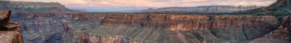
I took the drive up toward Harper’s Corner, stopping at the overlooks along the way. The canyons of the Yampa River opened up east into a series of grazed parks. Broad fells with gentle, humped slopes – Blue Mountain and Round Top Mountain – spilled toward the Yampa. The land tilted and swayed like English moorland, sans the green fields and gray skies. Yet no place to lay my head. All the signs sang NO CAMPING and all the maps joined that in chorus.
At the end of the road, I found Harper’s Corner Trail, a modest 2 mile round trip with little change in elevation. The day was old and I’d driven 11 hours in hot, dry and dusty plastic dinosaur land. I’d had near kidney failure and had to rescue a toe-headed, one year-old boy from the middle of the giant tarmac of a gas station in some crusty wayside so he didn’t get hit by marauding crossover vehicles rushing on their way to Flaming Gorge. I needed an easy hike. I slipped on my camelback and waded out onto a headland high above the confluence of the Green and Yampas.
The trail led out onto a promontory, which pinched out and dropped over 2,000 feet to the rivers below. The Uintas and the snow yet upon them gleamed as the sun headed near the shoulders of the mountains. Douglas fir and other alpine veg dotted the steep slopes of the canyon walls. The Green wended through Split Mountain in Mountain Canyon. I crossed the safety barrier and stood as close to the end rock of the cliff as I could. The need for sleep and a camp called. I headed back.
I drove back over the heights of Yampa Plateau and Blue Mountain Plateau. For hundreds of square miles, the open sky and fissured earth of northeast Utah made me feel like a spinning crow riding the helices of thermals a thousand feet above the high desert. I took Moffat County Road 5480, a crackly gray gravel affair, down below Cliff Ridge. NO TRESPASS warned me off some land, but I found a turnout onto some elevated ground in the marginal seas of the P-J forests. Lightning and its undeviating consort, thunder. Cool wind. The sun downed and I slept in the thickets of trees.
Drops of water on the canvass of my truck camper, the sound like cereal poured into a bowl, woke me at daybreak. I camped out on gray soils. I’d dripped some water on the ground the night before, and my test indicated the soil might be bentonite, a clay-like substrate that turns to pudding in the rain. So rather than become mired, I cranked down the pop-up and headed who knew where.
My CD player wouldn’t spit out the chill-out collection I’d slipped in during my last trip out to Lake Powell. I guess it liked Moby. Since my old Silverado also had an old cassette tape player, I’d brought some old Jethro Tull and even older Elton John. And some lessons from A Course in Miracles.
I slipped them in and, thick as a brick, I sung along with Ian Anderson, skating away on the thin ice of the new day. I took highway 40 back into Vernal, then 191 south toward my next destination, Desolation Canyon. The photos showed a vast and deep rent in the already scarred earth. Along 191, the land unexpectedly warped up on both sides to form hillsides bearded with fir and spruce. The only artifact I saw was an isolated ranch sewn in to a narrow valley that twisted for dozens of miles. After driving for over an hour, I saw my first vehicle at the base of a coal plant near Helper.
At Price, I stopped in at the local BLM office and discovered that Desolation Canyon, a Wilderness Study area, was off limits. The young woman behind the counter gave various explanations. She said that the only place I could access the canyon was at Green River, a small town near I-70 semi-famous as a put in for river trips. I happened to know that Desolation was nowhere near Green River, but the woman described the State park there as beautiful. So to Green River I drove.
191 opened up into wide desert. An endless reef, majestic and vaulting high over the flat range to the west of the highway, rolled in an up and down ribbon for miles.
The San Rafael Swell, a giant anticline structure that takes up a good stretch of south central Utah, begins with the jagged, sandstone tilt of the San Rafael Reef monocline to my west.
Green River MSA signed east. The town hot and low in the cottonwood hollows of the Green River. A beautiful old bank building with its windows blown out like bad teeth sat lonely on a corner far west of where the town had migrated over the years. I gassed up and headed back west. The State Park ended up being part golf course, replete with golf carts. I turned around and sped out of town before someone put a sand wedge in my hands.
I need aloneness, the kind where miles and miles separate me from my fellow craver of solitude. Last night where I camped, at the foot of the scarp that defined the plateaus above the Green-Yampa confluence, there might have been people within 10 miles. I love that. Bears and all. So a golf course would not do. Why was God making me work so hard to find that seclusion which lay always in the palm of my hands?
A sign on westbound I-70 said NO SERVICES FOR 100 MILES and I recalled reading somewhere that this was the loneliest stretch of interstate in the lower 48. Yes! The jagged San Rafael Reef stretched Martian-like north and south on either side of the road. Settlers had deemed it a reef since it reminded them of the shoals on which ships sometimes wrecked. The next exit was 24. It led south toward Hanksville, a gateway to the Glen Canyon region in southern Utah. I’d never driven that stretch of 24, so I took the exit.
Endless plains of high desert populated with joint fir Mormon tea, Russian thistle, Indian ricegrass and sage stretched toward chain mesas and buttes that stood red in the foreground. The distant Henry Mountains loomed background blue.
GOBLIN STATE PARK. I’d read about it and seen the pictures of the toadstool formations. I took the left. I paid the entrance fee and saw the campground. I’d be butt-up against fellow camper’s backside. No thanks. A sign just outside the Park had pointed toward Little Wild Horse and Bell Canyons. I went down that road for about 11 miles, and stumbled into a trailhead. Stumble. Now I was on to something. Serendipity. Synchronicity. All those quinta-syllabic ‘S’ words that meant there were no accidents, that nothing happened by mistake.
The trailhead signage showed a map and a description of an 8-mile loop trail through slots. No matter that lightning beckoned and thunder knocked in the distance; a bad time for a slot canyons. I suffered from the TU’s – terminal uniqueness. I’d be alright.
I shouldered my camelback and belted on a fanny pack of backup water. In 20 minutes, I was deep in the slots. Polished fluting. Sharp walls that jerked first left and then right, spaced by just a few feet, made me zigzag along the floor of loose sand as walls towered hundreds of feet up. Dark sky and booms of thunder spurred a curious claustrophobia I’d not experienced in the slots at once Buckskin or Wire Pass much farther south and west. So I walked real fast until the circuit canyon opened into wider areas, or until I could scout climb-outs along the walls.
Slot canyon systems remind me of cities. Walls unbreachable and without breaks limned the canyons like edifices, with an occasional intersection where two canyons met. Banded sandstones – ivory and rust – striped the walls. Crossbedded dunes ossified into sandstone sculpted a history of windblown deposition.
At the terminus of Little Wild Horse Canyon, the land opened up. Between gaps in the redwall, hints of Boulder Mountain shone in monolithic cobalt in the distant western sky. An old mining shack far off trail seemed still occupied. I followed the dirt track road that merged with the foot trail until Bell Canyon fed back into the slots on the return side of the loop. A wide wash seemed graded, it lay so flat and perfect. Another parallel with cities, it represented a wide onramp back into the jumble of buildings and downtown streets that formed the cliffs.
Over boulders and under them, squeezing through tight slots that rivaled any in a casino. I made it back to the trailhead in three hours.
I visited the Goblins: Entrada sandstone domes which overwhelmed in their sheer numbers. Thousands of mushroom shapes, taller than a man, harder than the packed silt they seemed. Odd armies of extraterrestrial ilk massing for some battle they didn’t know would never be fought, for the war had long since been called a draw. Out here, man against stone had come to an uneasy truce. Humans had, of course, long ago engulfed the million square miles west of the High Plains. And yet, if it remained anywhere, desolation still reigned here in the San Rafael Desert, in Sinbad Country. Here, there was still a chance at solitude. Yeah.
At that moment, the armies of children and their doting parents-cum-servants, the troops on our side which still waged war against solitude, kicked up dust as they mounted the capstones and snapped their shots, shouting victory in all their innocence and ignorance. T’would not be long before the newspapers reported that a Boy Scout leader or two wrestled one of the Goblin men to the ground and murdered him before it attacked a member of his troop.
I jumped in my truck and road back out to a desolate campsite 11 miles outside the State park, across from the trailhead where I’d begun my loop hike through the slots. All the other hikers – the shock troops which stood against my lone nature – had gone. I stood deliciously alone.
I walked a mile down the road, looking for a good and high place to watch the sun die its serial death. I, shirtless, the breeze a cool and unworn palm grazing my shoulders. I climbed up off the road and found the high point. I watched the rain clouds rise above the reef. They took up increasing fractions of the western sky. I studied the jagged, Basin and Range-like monocline of San Rafael Reef, dyed with a deep maroon strata that came off in my hands like chalk as I climbed. Geodes of deep crimson. Rocks buffed into ovals like dimes. Fire ant colonies coalescing at the surface for the flight this night of their drones.
The sun broke its tender yoke on the sharp reef and cast the broken summit gold with its stain. I went home to my truck.
About midnight, the stirrings of voices, the flash of lightning at the peripatetic frequencies of a quasar. Lightning doesn’t strobe like that. No, these were headlamps, like acetylene torches roving and bounding against the canvass walls of the camper. I glanced out the window – a man and his two boys readied for a night hike. That was the most likely scenario. The guy wouldn’t muzzle his kids and I hated that. This was my planet, damn it. Tonight, this whole section of southeast Utah belonged to me. Didn’t they know that? Didn’t they know how far I’d come? That’d I’d driven 11 hours yesterday and another 8 today through the heat, up and down bad roads and into dead ends? That I’d then driven another a couple hours just to find this place? Didn’t they know how hard I worked – day after day – just so I could come out here for three piddly nights and enjoy my SOLITUDE!?
That’s it. I’m gonna stand in the middle of this tiny camper until they go away. I am going to eventually walk out and give that man a piece of my mind for not keeping southeast Utah QUIET!
Eventually, I did put on a smelled up shirt, and with my jaw three days filled in black and gray, with my long hair three days unwashed and spiked from bed and sweat and desert hat, looking like an unintentional punk rocker from a generation his kids wouldn’t even recognize, I walked out and stood across the road as their headlamps bounced off rock and trailhead sign and vault toilets. Eventually, their headlights scanned and froze upon this Ichabod, this murderous figure in gray boxers across the road. They fixed upon the silent, hard stare just as they hit the trail. The boy saying to his dad, I’m sure—
“Dad, there’s some weird thing just standing there across the road. Is he one of those goblins?”
* * *
Next morning, I woke with the situation I usually envied in others: I had no idea, no plan, of where I’d be that night. I collapsed my camper and drove south down 24 through Hanksville. As the remote Henry Mountains loomed larger in the sky, the notion of driving up to Bull Creek Pass and camping near the summit of Ellen crossed my mind. I asked about road conditions, especially with all the rain we’d had, and was told not to worry by the man behind the gas station counter.
Easy for him to say. The roads up the Henry’s remained notorious for flatting. As I drove on, I did try one route up, but the signage never said Bull Creek and the road quickly became washboard and my camper began to shake apart. That and the soon-to-be-wet soil and the fangs sticking up out of the track, ready to inject themselves into my tires, forced a turn around.
I decided on one of the canyons carved by the Dirty Devil across highway 24, but road problems and a long long way before I would hit any canyon rims made me turn back again. The Little Rockies, a small subrange of the Henry Mountains, stabbed shark-toothed through the Cane Spring Desert across the highway from Mount Hillers and the main body of the Henrys. The Little Rockies had always enticed me with their Death Valley topography, much lower and more exotic in surface and shape than the rest of the Henrys.
They seemed accessible, easy to climb, and promised striking views of Navajo Mountain and Glen Canyon to the south and west. When I’d climbed partway up Mount Hillers a few weeks back, my eyes traced distant roads which my feet would easily follow up to the sharp peaks of Mount Holmes and Mount Ellsworth, the named peaks in the subrange.
I drove up and down Highway 24 looking for a place to park. You have to understand the topography in this region of Utah. No parking lots. No shoulders. No parking. Just an intermittent stream of F-350’s and Rams towing superjuiced speed boats back and forth from the marina at Bullfrog. I finally decided on a meager margin right off the highway. I swiveled in my side mirror, packed on water, and made my way for the track across the highway.
On my way in, I walked past an SUV negotiated the powder sand ruts, driving down from the mountain. Most people figured: Why walk when you can drive? I always assumed just the opposite. The driver stopped and checked me out. The woman leased the land for a school in the foothills of the mountains. She raised Navajo-Churro sheep, an endangered breed once raised in number by the Dine’.
I told her where I was headed. This was the 4th of July in the desert, up a mountain. She asked whether I had enough water, and whether I was in good enough shape. When she was satisfied I would not die, she told me that by splitting a nearby saddle and following a wash up through the foothills, I could take 45 minutes off my trip time to the summits of the Little Rockies.
“You’ll come up behind our corrals,” she said. “Awhile after that, the trail’ll fork pretty clear off the wash. You can’t miss it. Be careful: the rocks flake a bunch once you reach the highlands.”
I thanked her and headed off. My good karma was back!
I kept on up the sandy wash, crossed over logs dragged downstream by flashfloods, danced up over boulders polished smooth like soapstone. The reek of sheep marked the back of the sheep pens. As the woman had promised, the dirt track/trail was pretty obvious and I diverged from the wash and headed up the mountain.
Up into cool P-J, through boulder fields, until the trail forked, and then pinched out at the end of either tine.
So I scrambled. I scrambled through the boulder field, my eye on the skeleton of a fir that seemed to have grown between two igneous fangs at the summit of the mountain. That was my landmark. I made it to a pass between the jagged rock, far below summit. The route up wasn’t much of a route. Sandstone turning to the dark of volcanics. Steep. Sharp. All climb. I huffed and I puffed and blew myself down. Drew down on me water. Climbed. Fuck it. Stubborn, man. Stubborn as a churro sheep. Kept at it until there was no room for more climb. Well, there was actually, but I’d have run out of water on my way down.
I wagered the odds of a climb to the summits in my mind. No one knew where I was. No one ever did. There was that lady shepherd and she might call in search and rescue after my truck stayed on that roadside perch a couple more days. But I’d be dead by then. Everyone else who knew me thought I might be somewhere near Dinosaur because that’s where I said I was going.
So I got smart for a change and I climbed down the mountain. It was a beautiful trip, but I’d not made it to the top. No view. No bragging rights.
“You don’t have bragging rights until you make it home safe,” I always told myself. “And besides, discretion is the better part of valor,” my dad used to say. I guess he knew what kind of man I’d grow up to be. Maybe what he said – the man who’d died just six months before – maybe those words saved my life that day. Usually, I wouldn’t stop until the top.
I figured I’d get home tonight, wash off all that grime cured from sweat and sand and sunblock, and sleep in my own bed with my own two cats. As I raced up highway 24 toward its confluence with 95, the main stem of the Henrys towered over the canyons into which their foothills poured themselves. Mounts Hillers, Pennell and Ellen a featureless blue as storm clouds washed their shoulders.
“How beautiful,” I whispered. Just as my tongue let slip the words, my eye snagged a road sign just past Maidenhair Spring: BULLCREEK PASS.
I screeched on the brakes and took the hard left. The road stayed good. I found a Utah Department of Transportation site. The sign said PROPERTY OF UDOT. Didn’t say nothing about no camping. I found a good flat stretch of gravel, evened out the balance from front to back of the truck, and cranked up the camper.
I laid out some carpet liner on the rocky sand and a couple of sweated up old pillows, pulled out The Enlightened Heart, an anthology of poetry of the sacred, and I watched storms float in convoys south to north over the mountains. I listened to the muted report of thunder typical of mountain storm.
Awhile later, as I studied the clouds which became winged gods and jawed demiurges and then just clouds again, I got up and walked a few feet over the rise next from my campsite. A canyon yawned into view, and I hiked to the edge of a point. Hundreds of feet below, cottonwoods wound in gullies toward Maidenhair Spring. A mile or more across the defile, the red and gold foothills of Mount Hillers stepped up. Only a bolt of lightning forced me back to camp.
I had always wanted just this – to camp out at the foot of these far ranging mountains called the Henrys, beyond the sound of highways and the babble of campgrounds. Half-naked on a pebbled ground, the far off pungency of rain. Sprinkled by water from distant ocean. Fanned by storm winds. Occulted from the constant desert sun by steel clouds. The violence of lightning, the cower of thunder at safe distance.
Hour after hour the storms rolled past. Winds came and went. A couple dots of rain quenched my dry and red skin. The watch said 7:30, but I swear I laid out there for four hours more before the sun downed, locked in some kind of freeze of time.
Finally, over the many shoulders of the Ellen group of summits, rain clouds trapped what seemed like the last of graylight just over the summits, painting a silvering aura. I promised myself that I’d go inside and sleep once that light dissolved into mountain. But the light seemed to shine brighter, especially over Pennell, where distant gunmetal clouds seemed to magnify the last of the sun.
I broke my vow and went to sleep. Yet every 20 minutes or so, I’d unzip the emergency exit of my canvass and peer out toward the west like a boy peeking through his tent fly, only to see the same gray aura over Ellen and Pennell, almost like the sould of the mountains, like their auras, as the light traced the shape of the summits just above the rocks themselves. Only Venus shone bright in the dusking sky to remind me of twilight.
“Must be 11 o’clock,” I told myself. Yet I had no way of keeping this kind of time. A time outside itself. I drifted off into nothingness.
Hours later I woke from my shroud of sleep, unzipped the canvass. Darkness finally prevailed. All clouds banished in favor of a stellar firmament of clarity. No one for miles and miles. Had I made it up to Bull Creek Pass, I’d surely have been drenched by storm and forced inside a humid shell of canvass.
Life makes me try many things before I find my perfect fit. Looking back, I don’t regret the dead ends and false starts, or the roads not taken. I travel down one track for awhile, only to discover that it’s not my destination.
When I find what’s really right for me, I’ll know it. I’ll have all those blind allies with which to compare it. I fall in love with the last road taken.
Dinosaur seemed a million miles away.
© 2014 by Michael C. Just