A geologist I know once said that southeastern Utah is the busiest place on earth, geologically speaking. In late October, I decided to take a drive there from Mancos, Colorado. Mancos, tucked away in a seam of the Four Corners quilt, has, maybe, 1,500 people. Then I passed by Dolores, with even fewer citizens, and then there’s the booming metroplex of Cortez, with just over 9,000. Out here, the towns post their elevations, not their populations. Those towns are all Montezuma County has.
As I threaded through the streets of Cortez, I slipped under the cliffs of Mesa Verde which sprawled like a giant’s knuckles at the edge of Montezuma Valley. I flitted past the airport where security screeners set up their mini anti-terror flea mart a few times daily, then I descended down Mc Elmo Canyon, through Sand Canyon where water and wind tamed the bands of sandstone alternating from russet to ivory, shaping them into kneeling elephant shapes. On the other side of the road, the base of Sleeping Ute Mountain marked the beginning of Ute Mountain Ute land. Out my window stretched vineyards and ranches tucked in a narrow U-valley between Sleeping Ute and some deserted hills to the north. I couldn’t see much though, as rains pounded the windshield of my Cherokee. I drove and drove, the scraping bellies of gunmetal clouds ripped open by the scrabbled tops of the shallow tablelands.
The valley’s ranches had first water rights from the mountain runoff farther east so the valley greened like a slice of Wisconsin. But autumn-yellowed cottonwood followed the serpentine belt of the watercourse. Only the snowy heights of Sleeping Ute, which uncannily resembles a supine giant with his knees and toes to the heavens, his arms folded over his drafty chest, and his head to one side, reminded me this was Four Corners and not Slades Corners, Wisconsin.
I slipped on past the vineyards and ranches. At the western mouth of the canyon, a flagger stopped me in my tracks and my sails drew down in the doldrums of road construction. I waited 20 minutes, hopping out in the soak to ask the STOP man on the crew where I could pick up Highway 262. He didn’t seem to know, or he seemed to tell me and I didn’t seem to understand. Out here, near Hovenweep National Monument, where Anasazi apartments dotted the muddy scrawl, the lands remained shy on sign and direction.
I faked my way north of Mc Elmo Creek, stopped for gas in Montezuma Creek, a crossroads just inside Utah. I asked for directions, but failed again in my understanding. Why is it that people like me can talk about twice as good as they can listen?
I felt my way down the road instead, using reason to plug the gaps where my gut-sense cut out like AM radio does in the mountains. I sailed up the shoulder of the highlands, and the Navajo lands opened up like an ocean in pitch and roll. The clouds drew open and allowed the light. Navajoland offers sweeping vistas as can no other land on earth. It sways, dances into the sky, and the sky pours itself back into distant scarps as if the two – earth and heaven – are one. The Mittens of Monument Valley seemed shadows on the far shore of this terrestrial ocean.
In my first half-life, they told me that the only stuff that’s real is the stuff I could touch and see. I gazed ’round and ’round and the earth floated me like a cork and the earth seemed real.
I found my way again, drifting south of the Abajo Mountains, blue as their name. Usually, I’d cruise into Utah through the front door, through Monticello on my way to Canyonlands. On those days, I’d watch the sun low over the jigsaw well that’s carved by the Confluence of the Colorado and the Green. I’d catalog the spires and cliffs in the foreground, then I’d aware myself of far off mountains floating on the western line, cobalt like the parting clouds overhead just now. Those laccolithic ranges were sky islands, hundreds of miles removed of the Rockies, carved into the master frieze of the Colorado Plateau.
West of the Abajo, I glimpsed the next ranges cut like sapphires into the sky – the Henry Mountains. The last mapped region in the lower 48, Grand Canyon explorer John Wesley Powell called them the Unknown Mountains. The Navajo called them by a similar name. The Unknowns serve as my landmark. I’m navigating just east of there, to the Dirty Devil Wilderness that stretches for miles along the Dirty Devil River, so christened by Powell’s men due to its turbid soul. In the Dirty Devil Wilderness, lies Robbers’ Roost, an inaccessible canyon system west of Canyonlands. It’s so remote, Butch and the Wild Bunch Gang hung here to avoid the Main Cop back in the day. And Happy Canyon removes itself even further in from the thin asphalt ribbons on which I ply. Happy Canyon yawns vast and impenetrable to RV’s and their hookups. That’s where I go. To get happy.
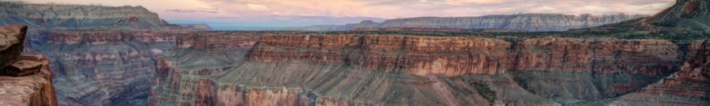
West of 191, I snaked up Comb Ridge, an 80-mile long monocline slanted into the earth. From its spine, I survey earth-girdling vistas of the Carrizo Mountains of northeast Arizona. I climb the ziggurat shape of Salvation Knoll and take in Cedar Mesa, a forested plateau twisted with white gorges like Fish and Owl Creek and Grand Gulch I can see all of Four Corners, and even past this vast region, to the La Plata Mountains in Colorado. Below Comb’s Ridge, Comb Wash lay green with Fremont cottonwoods.
I jumped back in my Jeep, glided through Manti-La Sal National Forest, thick with pinion and juniper, and darted past the entrance to Natural Bridges National Monument. From there, I road Highway 95, which tracked White Canyon, a wending defile that drains the Abajo Mountains and follows the road all the way to Lake Powell. Above White Canyon, rose rock mesas mixed dirty with pinion green ascended. Jacob’s Chair, a butte of Wingate Sandstone, pierced high and sharp into the bluing sky. The P-J canyon held me a long time before its white sandstone gave way to something far less terrestrial.
The land dried into a jagged red at Hite Crossing over the Colorado. The sheer, blushed face of Trachyte Point, a sandstone scarp, walls in Lake Powell on the west. Brooding over that cathedra, lunar peaks of steely hue, scarved by snow clouds, towered in a cobalt tier over the more immediate red world. These were the Little Rockies, rising only about eight grand above sea level, but so precipitous and jagged they earned their name. Above the Little Rockies, even higher peaks clawed the sky – the Henry Mountains loomed high and bloodless like pieces of moon broken off and descended to earth, all sheeted by the white violence of late October. I parked and hiked the rocks.
Roadside, Glen Canyon National Recreation Area swallowed me in scarlet. And the terrain plunged one more tier below the escarpments into an aquamarine sea. Glen Canyon drowned under the waters of Lake Powell. A stalwart environmentalist, I’d trained myself to hate it. Without Glen Canyon Damn, a very dry Glen Canyon would bridge Cataract Canyon and Canyonlands with Marble Canyon and the Grand Canyon, which itself narrowly averted becoming bottled water. Without the rude inundations of Lake Powell, ironically named for a man who would have considered engineering the Colorado a sin, I might be standing in the basement of the vastest canyon system on earth.
But I must confess my own sin. I found Lake Powell to be exotic and quixotic, bountiful and beautiful. I wasn’t supposed to like it, the environmental journals told me. But I did. Its jade waters offered a surreal contrast to the cold and red desert which held it.
I stood inside a circulatory system with hardened arteries. The tentacular Lake Powell, with so many stony embayments, were its vessels and veins. An unnamed butte waded into the calm waters like a sea stack off the Washington coast. I stopped and watched the water ingress upon the land like a drowned coast, the manufactured fiords affording psychedelic respite from the world back home that made sense.
In such a Martian landscape, I needed reassurance—reassurance that I still stood on earth, for one thing. But I also wanted to be told that everything would turn out alright. This spirit thing, it’s so damned maddening. It’s very difficult for a highly advanced spiritual being such as myself to be made flesh.
The lake began just after the Hite Bridge crossing, widening below the sheer ruby escarpments on one side. A sea of tamarisk waved on the other bank. Tamarisk was an invasive species. I wasn’t supposed to like tamarisk either. Watermarks up on the cliffs showed where Powell had diminished from its height in the1990’s. Downriver, islands surfaced like turquoise submarines. I walked the cold, windy lakeshore as far as I could, then hopped back in my four-wheeler and flew on.
I got back in my four-wheeler and rolled down the Trail of the Ancients Scenic Byway, cradled by the golden cottonwoods of North Wash, which dipped their roots like straws into the cold mountain water that intermittently flowed through the wash. Absorbed by the mélange of gem-stained lake and desert canyon and blue snow crags, I missed the turn off to the Dirty Devil Wilderness.
I doubled backed on 276 and found Poison Springs Road. I launched on the 30 miles to the Dirty Devil. The road was so bad, with stair-step drops of about two feet in places, I didn’t think my Jeep, trail rated as it was, would make it. And at the speed of about five MPH, it would take me six hours just to make the Dirty Devil River itself. Then I’d need to go another 10 miles or so to Fiddler Cove and North Hatch Canyon where I’d camp for the night. It was already 2:00 p.m. I’d lose light in about four hours. It didn’t add up. Fuck it. Bad planning on my part should not constitute a later and probable emergency on my part.
I turned back west. The Henry’s stood so high and lonely, the cavities in their summits snagged with snow, that I had to get a closer look. Starr Springs Campground lay just a few miles away on unpaved road, but good unpaved road. I landed the campground and scoped it out. Not a hominid in sight. Paid my six bucks into the wooden collection box and set up camp, which was a sleeping bag in the back of my Jeep with the back seats down.
It hailed like hell that close up against the base of Mount Hilliers (10,723 feet).
Before sunset, I climbed some ridges and got a great soul shot of Navajo Mountain hard on the Utah-Arizona border. Another lacolith, but rare in that it still sported a sedimentary cap, this sacred mountain, called Naatsis’a’a’n by the Navajo, this head of the earth, wreathed in storm, remained a leviathan at rest.
Chasms in all directions radiated out for dozens of miles. The Little Rockies lay just across the highway. Between their peaks, the west rims of Glen Canyon teased. Northeast, orange ridges decayed into jumbles of canyons. Beyond Cedar Point to the east, there was Sam’s Mesa, the Big Ridge, the Block, the Cove, all places within the Dirty Devil Wilderness I’d hoped to see up close. North, the Upper Blue Hills and the South Pinto Hills bucked the back of the untamed horizon.
It snowed. It rained. I froze. I ate prefab tuna salad out of the tin. I studied topo maps and metaphysical tomes by flashlight in my cramped cab. I was reading Ken Wilbur.
In this, my second half-life, Wilbur told me, and I came to understand, that the things that mattered in this life were the things I couldn’t see and couldn’t feel.
Come dawn, I drove through the settlement of Ticaboo, abandoned until the boaters re-colonized it next summer. I made it down to Bullfrog Marina at Lake Powell. It stands out as the Great Incongruity; to journey through a desiccated land and there in its unquenched heart, to see double-decker houseboats big enough to host the Pope’s wedding, stranded on cinderblocks by an all-encompassing desert.
I turned north on Bullfrog Road. I wanted to get up against the Waterpocket Fold, which stood like a sail atop the spine of a buried dinosaur, separated from the Henry Mountains by the canyons that dipped between them. These canyons, which dove below the bases of the mountains, seemed to loft the mountains even higher. The road to the Waterpocket Fold soon washed out. That left me with a day hike in a shallow canyon.
My weekend was over. Time to head back home. On the way back across Cedar Mesa, I stopped half a dozen times for last glimpses of the Henry’s and the canyons.
Just after I crossed back over the Colorado, I parked, stepped out and studied the flat rock faces that hemmed in Lake Powell. I perched on a rock and looked upriver, watching the lake winnow into the gorge of the Colorado at Narrow Canyon. From my vantage point, the land stepped up and up, and each time, it flashed a startling change of hue. . I stopped in Farley Canyon. Its flat, sage bottom clashed with the jagged verticality of the shark’s tooth scarps comprising the canyon walls above me, overlain with the mountains above them. All contrasts here seemed abrupt, all change fast and violent and beautiful and warm in the sun and cold in the shadow of Brown’s Rim.
As I stepped back into my land sloop and turned for home that afternoon, I remembered the world made by men that existed outside this earth made by God, a world violent and changing fast, rent by war and apocalypse. As the stone crumbles, so does empire.
Rest assured, the tour books told me. This nightmare of ecological disaster and economic collapse is but a dream. Well, that’s what Ken Wilber said anyway.
But I needed some reassurance. Sometimes, I need to touch God, to hold God’s hand. But it can’t be done. I think sometimes it’s harder to be a human than it is to be a fungus. I think it can be harder to be a person than to be God. I mean, I know we’re all the same thing. I know Spirit is being fungus and it is being a man. Yet if I really knew that in my heart, I wouldn’t need God to hold my hand.
I scooped my hand down to the earth and played with some red gravel. I peered out over the Colorado, looked down at that silver suspension bridge beat into the rock. I gazed into the vertical walls east of the Hite Crossing at Cataract Canyon upriver. I picked up some of the red scree and worked it into dust between my fingers. I held onto something there. I held something. I held spirit.
I hope never to forget this trip to the Henrys. When I’m tempted by bad headlines, I put my mind back along that winding stretch of Utah Highway 95. Any stretch, from the Rez to Comb’s Ridge to the Confluence of the Dirty Devil and the Colorado will do. It all drops off my shoulders, the worry does. Then and there, I hold God’s hand.
[Drive Highway 95 across Cedar Mesa and across Hite Crossing. At the junction of highways 95 and 276, turn left on 276 and drive until you get tired. Starr Springs is on the right at the southern end of the Henry Mountains].
© 2014 by Michael C. Just