Amazing how chance works. I need to let someone know I’ll be out of phone contact for a few days, but my cell has no service. Four mountain bikers show up, one of whom has a perfectly splendid and working cell phone. Then I ask God for inspiration, for an intuitive thought to guide where I should end up today after a few days at Parrisawampitts. Hadn’t really seen anyone for days, but when I get back to camp, two hunters drive up.
“I’ve been thinking about heading to Indian Hollow,” I say.
“Oh, Indian Hollow is nothing. It’s not even on the rim,” he say. “Where you really oughtta go is Saddle Mountain,” and he goes on to describe the views I’ll see from there. He gives me directions and I set off, buoyed with the excitement that accompanies the beginning of a journey.
After resupply at the store near LaMotte Campground and some mix up as to where Forest Service Road 610 actually begins, my truck slices through spruce and aspen and other mountain forms, ending up suddenly at a clearing, at the top of a mountain. The world opens up 12.1 miles from Highway 67 along FS Road 610.
A sole campsite edges a cliff top. I pull in, garnering views that sweep east and south onto Marble Canyon as it winds its way north of Lees Ferry at the junction of the Vermillion and Echo Cliffs; of majestic Navajo Mountain resting atop the sun-dazzled Echo escarpment; of the putting green plain of the Marble Platform before it pours the Navajo world down into the Little Colorado River Gorge.
A few yards from my windswept campsite, draped in soggy broadleaf trees, a sign says POINT IMPERIAL – 2.2 MILES, and beyond the signpost, a wide swing gate welcomes me into Grand Canyon National Park itself. Even Grand Canyon has a backdoor.
I stride out onto a vast headland closed in with aspen and thorny broadleafs, capped out by high spruce and ponderosa. Wet and wild and rainy and gray, a perfect atmosphere for me to swim within. I have to swing back the branches, the vegetation is so thick. It reminds me of the North Woods of Wisconsin. Drizzled in with the mixed hardwoods are taller aspen trunks blacked by fire.
The forest trends down to lower, newer growing aspen, which often colonize a region after a fire. The howls of a coyote end up being the sweet sound of a standing aspen rubbing like a violin bow against a downed trunk. More aspen saplings golden in the fall, all low against the dark gray sky.
The aspen forests gave way to the cindered graveyard of a dead forest. A conflagration had raged through here some time ago. Charred stalks of dead ponderosa stood like matchsticks against the limestone sky. The ground coaly everywhere, here and there striped with white ash. I could still smell the fire.
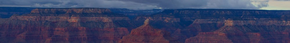
The vast peninsular form out to Point Imperial lie denuded, granting freedom to see the North Rim in all its vastness as the headland’s eastern slope plunged off into a spinning side canyon. The fire a merciless hunter. Even the root dens of the ponderosa had been plundered by the flames, leaving giant claw marks from some voracious tyrannosaur. The ceaseless wind brought a stand of aspen to a shriek.
Here and there, stands of ponderosa, their pink bark whitened by the ash of fire, had survived the holocaust. As the peninsula turned east, even the Grand Staircase cliffs became visible, and what looked like the Aquarius Plateau far into Utah stood as a mountain chain. I reached Point Imperial, still crowned with live ponderosa that tossed and moaned in the wind.
Northeast, the Vermillion Cliffs danced between shade and sunlight, as did the Echo Cliffs and the pedestal they formed for the monolithic blue hump of Navajo Mountain. Through the wide and vast Houserock Valley, the orange fracture of Marble Canyon snaked its way across the broad, green platform that bore its name. On the plain’s back, rosettes formed from cloud shadows.
Southeast, I made out the mouth of the Little Colorado joining the Colorado, the distant streaks and dashes of the Painted Desert, the cathedric spire of Mount Hayden, the Coconino Rim darkened by storm, the San Francisco Peaks.
At Point Imperial, I picked up Ken Patrick Trail. I wanted to take this two mile trunk as far as Cape Royale Road, but ended up on a spur which wandered out onto a narrow hogback. Glad I did as I might have lost light had I taken Ken Patrick the whole two miles.
I meandered back Past Point Imperial. Ebony storm clouds moved me on, and in that fire-made plain of dead forest on my way back to camp, I contemplated the austere beauty of Brahma in a hard, gray sunset over a low stand of aspen. Drilled by hail, watching wind wail through a dead aspen trunk with a missing bore hole that made it a giant flute, I thought about what had brought me to this place.
Synchronicity. Serendipity. They used to call it Providence. When I began this trip to the North Rim, I made a decision to accept all of Life’s gifts to me, without exception or expectation. Right after I’d done that, something inside told me to remember that moment of choice. I surrendered all my claims that I’d made on others and upon myself and upon the sweet, bitter Universe, in favor of what It wanted for me.
The closer I draw to this Nonrandom Event Generator, the richer and more elegant the stone shapes and harmonies of wind, the colors of sky and the trail’s wanderings. Finding the Ken Patrick Trail by accident after gleaning its name from a guidebook I just happened to browse in a Kanab coffee house I also stumbled upon. Meeting a hunter who told me about Saddle Mountain, right after I’d reflected about where to go next. Finding the single campsite adjacent to the kitchen entrance to Grand Canyon National Park and the Point Imperial Trailhead.
The less I plan, the more I live.
© 2014 by Michael C. Just