Clay Canyon remains unrediscovered by the larger proportion of ecoturista americana, an invasive species that makes multiple, loud trumpeting calls and exhibits strange mating behavior. We live in the Age of Rediscovery. Rediscovery is marked by high turnout. Think South Rim, Grand Canyon, and Yosemite.
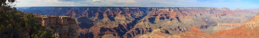
Clay Canyon remains unrediscovered. It’s empty and raw, red and wide. Formed by the intermittent Bullfrog Creek, it sets the table for the Henry Mountains, which rise in the distance across its deep chasm. It is a lonely place despite a paved road that parallels the arc of the gorge as it nears its confluence with Lake Powell. Clay is beset with side canyons, with sheer, thousand foot walls, and easy-to-scramble rims.
Strong surface winds blew SSW. Higher altitude winds blew in violence in the opposite direction. Under a percussive beat of thunder, I watched a curtain of rain close slowly over the Bear’s Ears, a twin-monolith which presided over Cedar Mesa to the east. As the rain began falling over that land many miles away, it rained on me. Soon, the storm blotted out the whole horizon.
I lay in my truck camper, with the windows wide open. The gale blew the faded green curtains around like day clouds. Light rain sounded like Rice Crispies on the shell of the camper. Clouds of white-silver wreathed the Henry Mountains. They darkened the southern group of the Henry’s, AKA the Little Rockies, a southern spur of the Henry’s. Soon, Mount Ellsworth bruised to a silhouette the same color of the storm. Lightning flickered and jagged. Next I looked, Ellsworth was gone.
The storm passed, and sprinkled a fine talc of snow on the north face of Ellsworth and on the summit of Pennel, the middle massif in the main range of the Henry’s. Set back farther east from Pennel, the highest peak in the range, Mount Ellen, jacketed itself in a heavier rime of snow. In late May, small snowfields still clung to her near 12,000 foot summit.
At the base of Pennel, decaying sedimentary ramparts wandered out like the headlands of distant shores. This country often forms gigantic staircase patterns. The ramparts at the foot of Mount Pennel formed the topmost step in a three stair flight where the risers were cliffs that stepped down to the floor of Clay Canyon and the greened meanders of Bullfrog Creek.
I spent a couple days here alone, exploring the country without running into another soul. Though I crave this solitude, it tricks me sometimes. I’m reminded of patternicity, a term coined by Michael Shermer in his book, The Believing Brain. It refers to the mind’s tendency to fill in gaps and to find patterns in randomness. For me, after a couple of days alone, the sound of far off music turns out to be the whine of a fly.
I walked along the scarp edges of Clay Canyon, and skirted the edges of the pouroffs of slickrock where stronger rains sometimes drop down these indents like water through the lips of giant pitchers. After the pent up energy of the storm had relieved its stress, everything calmed. Even the plane overhead sounded lazy and careless in its drone. A brood of raven chicks pierced the peace with their cliffside shrieks.
I wandered over slickrock through a desert in bloom; in full flower with stone. I climbed a white, sandstone kopi next to my campsite. Fields of what seemed like fossilized dinosaur eggs, some with ossified egg whites, littered the ground. I could easily chip away the runneled tan shells from the yoke, revealing dark iron cores or white ones. Perfect red spheres of stone grew out of the faces of scoured Navajo sandstone boulders like barnacles. The rough-to-the-touch sandstone bore a whiter hue than the Navajo Sandstone farther east in places like Canyonlands. Globes of ferrous stones banded gold and white, hollowed out like clay pots, spilled all over the desert floor, some smashed like gords. Rodent scat filled one. Some shells were so perfect in spheroid shape, the husks resemble potsherds. Others were sculpted like miniature kivas. Some were softball sized, embedded in the white rock. The smaller nodules looked like splats of rain painting the rocks in which they were embedded. Some were convoluted, shaped and sized like stromatolites, the bacterial mats of the most ancient life on the planet. Perfect half-globes seemed as if they’d been machined in a shop. Others were chevrons, upended tortoise shells. One shell, the size and shape of a beachball, was mortared in the sandstone face of the kopi, Its concave surface was painted bright gold and white with yellow paint and desert brain lichen.
Cannon balls of dark iron shot, perfectly round, cast in some foundry, sat near the corresponding spherical shells from which they’d hatched. I could lift the balls right out of the shells. Husks and yoked centers in concentric circles, like the medieval spheres that comprised the cosmos. It all spread on the canyon’s rim like the ejecta from a volcano; like lava bombs. I knew they weren’t volcanics. The geological history here was elementary sedimentary, not obvious igneous.
What I surmised as industrial or paleontological in simile was something called ironstone, in concretions called Navajo berries and Moki marbles. A strongly mortated ironstone shell enclosed a more loosely cemented sandstone core. The berries form in the subterranean world after the sand is turned to sandstone through pressure. The ironstone is made of quartz sand bonded to a hematite mortar. Hydorcarbons or acidic water filters through the sandstone and deposits iron-bearing cement that gathers between grains of sand. All it takes is a little iron, which turns back into a more solid form when it encounters oxygen in groundwater. As more iron precipitates around the core, the spherical shapes are the natural outcomes. Spheres are common in nature because they’re efficient. Think of the round rock you call home. Sometimes the iron pushes outward. The core, consisting of sand, is more weakly glued. This creates a thick shell around soft sand. This makes the shell and core pattern I’d been seeing.
I climbed down off the kopi and hiked east toward the mountains, my steps tracing the side canyons in and out. I picked up a tiny, cleaved, ivory stone. Black, concentric circles printed on its halved face. Not quite a mandala. I’d been reading Joseph Campbell’s The Inner Reaches of Outer Space. I began to wonder about circles within circles, globes inside of globes. I thought of onions and pealing their layers.
After awhile, I hiked back to my campsite and climbed the sandstone kopi for a better view of the surrounding terrain. Conglomerate mortared in the spaces between the standing sandstone and the horizontal slickrock that made up the kopi. The soft, white sandstone easily weathered into Swiss cheese holes called tafoni, into windows and handles and man-sized alcoves. A column of tooth white sandstone seemed in the process of becoming a Rodan or a Michelangelo.
Sage wafted in on the cool air. Navajo Mountain presided over the southern horizon. Usually a monolithic blue from this northerly vantage point at this time of afternoon, the word ‘brooding’ usually comes to mind in describing this mountain. The eroding remains of an ancient magma chamber, Navajo Mountain seems the mystic mountain, and not only because of its sacred importance to the Dine’. There are other lacolothic isles, remnants of subsurface vulcanism, which straddle the Four Corners region: the nearby Henrys, the Abajo, the La Sal, the Carrizo, and Sleeping Ute. Yet they are all ranges, in the company of other mountains. Navajo Mountain stands alone as a single entity, a symmetry of a cat’s sleeping shape under a blanket of sediment.
Beyond Navajo Mountain to the south, the Vermillion Cliffs form Paria Plateau, concealing the beginnings of Grand Canyon. Southeast, crevasses in the earth mark Glen Canyon’s side canyons which drain dry into Lake Powell. I wish I could’ve seen old Glen before Lake Powell reached full pool. Yet today, at Hite crossing at the vast lake’s northern end, the Colorado has reclaimed its old channel. Powell is drying up into mudflats there. There’s talk of draining regional reservoirs upriver in Colorado to refill Powell.
Landforms come into and out of focus, moving in and out of the foreground as cloud and storm rove across the deserts to the south. Distant mesas, white and ghostly behind sheets of rain, form subtle, almost indiscernible shapes. One foot of a rainbow marks the distant storm.
Swelling cumulus form above Navajo Mountain, making it seem like the volcano it once was. The mountain seems, with its sharp, northern cliff face chiseled out by an occasional sun, like an oceanic island deep out in the Pacific, maybe Hawaii.
Closer in, sheer canyon walls with vast, meandering subsidiary canyons form the abyss of Clay Canyon. The main chasm extends about 2 to 3 miles across. Westward, on a dark, blue canvass of stormed sky, orange Capitol Reef devolves to cliffs that drop down to jumbled feeder canyons near Lake Powell.
Thunder rolls out from there. Mammatus clouds swell and drip overhead. I stumble onto a petrified log, all by itself.
The desert blossoms with more than rocks this time of year. It turns purple with primrose, and white, with tiny blossoms of cone flowers. It grows yellow with millions of even tinier, ankle-high flowers which waver in the wind like gnats. Desert marigold round out the yellows Claret cup cacti bloom with pink and magenta, rose-like flowers. Engelmann’s hedgehog blossom in violet shades beneath trees and the scrub of ephedra and sage. The desert floor blooms red with skyrockets and paintbrush.
I stumble into a few more shells of ironstone: one in the chevron shape of a horseshoe crab. Another is a giant’s slipper, size 40. My mind searches for analogues in a land so different than any world I’ve come to know.
[My adventure began on BLM Road G12070, or just plan ol’ 12070, a little over 12 miles north of Highway 276 on the Burr Trail Road. NPS puts out an excellent guide, Driving the Burr Trail, at www.nps.gov/clca/planyourvisit/driving-the-burr-trail.htm.]
Have fun.
© 2014 by Michael C. Just