Toroweap offers solitude and precipitous drop offs. Normal people travel here in the cooler months. I, being supernormal, went in June, a mistake I shant repeat. Yet I suppose if you can withstand the unpaved drive down the Sunshine Route (BLM Road 109) from Highway 389, on over 61 miles of fang rock road, you can handle the Grand Canyon heat.
Tip #1: Don’t drive at over 20 miles per hour down Road 109. You may end up doing a lot of hiking you never thought of doing.
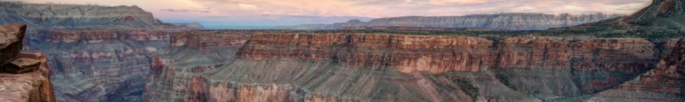
A walk to Toroweap Overlook itself treats you to plummeting views from the Grand Canyon’s North Rim to the river 3,000 feet below. Due to its inaccessibility, you won’t find much competition for camp space. There’s no charge for the 9 campsites. It’s first come, first serve. There is, however, a permit and fee required for backcountry camping. Get these permits at Pipe Springs National Monument or the Back Country Information Center. No online reservations. For more info, call 928-638-7875 1:00 to 5:00 pm, weekdays.
From Toroweap Overlook, the Colorado River extends straight toward the east for quite a stretch, a rarity for any river, much less one that wends through its chasm the way the Colorado does.
I decided to hike down to the river. The Lava Falls Route, which is more of a chute than a trail, dives 1.5 miles down to the river across sun-exposed talus. One of the most dangerous rim-to-river hikes in the Canyon.
Tip #2: Don’t do Lava Falls after you’ve aleady hiked about 7 miles up and down Tuckup Trail and used up half your water.
Due to fear of rendering myself parched, and since the Lava Falls Route required some minor rock-climbing ability which I chose not to find out whether I had or hadn’t in me, I decided to turn around about midway down to the River.
Still needing to prove my manhood, I next mounted Vulcan’s Throne, a volcanic cinder cone that rests right on the rim’s edge high above the river. Much of Toroweap Valley, which you’ll trace when you drive to Toroweap from one of the main highways, is a lava field left over from eruptions that ended only 750,000 years ago. These eruptions formed dikes that dammed up the Colorado. You can see evidence of all this when you look at sediment deposits high above the river along the walls of the Inner Gorge.
Vulcan’s Throne looks easy, but it’s like climbing a mountain of marbles several hundred feet high. And the cinders cut like glass.
Tip #3: Don’t wear shorts if you decide to climb Vulcan’s Throne. And wear gloves. Else you’ll cut the shit out of yourself.
After trudging up a down escalator for a couple hours, in heat magnified by the dark rocks upon which I swam, I realized there was no method to getting to the summit other than to take two steps up, fall back a step, take three steps up, fall back a few feet. The cinders self-sort and there are some that seemed easier to tread, size-wise. Then I realized I was full of it and that all the routes up sucked.
At the summit, NPS puts a register for you to sign, the kind you often see at mountaintops. You’ll understand why once you’ve bagged Vulcan’s Throne. ‘Tis a bitch in summer.
Toroweap offers little shade but magnificent views. And solitude. Yes, that. When I’d written my short stories about the Grand Canyon, I hadn’t yet been to Toroweap. Had I travelled here before I wrote my collection of Grand Canyon fiction, I probably would have set one of the darker pieces – maybe a murder mystery or suspense story – here. Toroweap is a haunted chasm.